ლავალიეხას დეპარტამენტი დეპარტამენტის რუკა იხილეთ აგრეთვე რესურსები ინტერნეტში 34°22′39″ ს. გ. 55°14′17″ დ. გ. / 34.37750° ს. გ. 55.23806° დ. გ. / -34.37750; -55.23806lavalleja.gub.uyINE map of Lavalleja Department
ესპ.ურუგვაიშიმინასიტრეინტა-ი-ტრესის დეპარტამენტიროჩის დეპარტამენტიკანელონესისამალდონადოსფლორიდის დეპარტამენტებიხუან ანტონიო ლავალიეხას183716 ივნისს

ლავალიეხას დეპარტამენტი
function mfTempOpenSection(id)var block=document.getElementById("mf-section-"+id);block.className+=" open-block";block.previousSibling.className+=" open-block";
ლავალიეხას დეპარტამენტი (ესპ. Departamento de Lavalleja) — დეპარტამენტი ურუგვაიში. დედაქალაქია მინასი. მდებარეობს ქვეყნის სამხრეთ-აღმოსავლეთ ნაწილში. ჩრდილოეთით ესაზღვრება ტრეინტა-ი-ტრესის დეპარტამენტი, აღმოსავლეთით — როჩის დეპარტამენტი, სამხრეთით — კანელონესისა და მალდონადოს, დასავლეთით კი ფლორიდის დეპარტამენტები.
 | |||||
| ქვეყანა |  ურუგვაი ურუგვაი | ||||
|---|---|---|---|---|---|
| ადმ. ცენტრი | მინასი (ურუგვაი) | ||||
| კოორდინატები | 34°22′39″ ს. გ. 55°14′17″ დ. გ. / 34.37750° ს. გ. 55.23806° დ. გ. / -34.37750; -55.23806 | ||||
| დაარსდა | 1837 | ||||
| ფართობი | 10 016 კმ² | ||||
| ცენტრის სიმაღლე | 250 მეტრი | ||||
| მოსახლეობა | 58 815 კაცი (2011) | ||||
| სიმჭიდროვე | 5,9 კაცი/კმ² | ||||
| სასაათო სარტყელი | UTC-3 | ||||
| ISO 3166 კოდი | UY-LA | ||||
| ოფიციალური საიტი | lavalleja.gub.uy | ||||
 | |||||
ლავალიეხას დეპარტამენტი ვიკისაწყობში | |||||


სახელი ეწოდა ბრიგადირ ხუან ანტონიო ლავალიეხას პატივსაცემად, რომელიც ურუგვაის დამოუკიდებლობისათვის ბრძოლაში განსაკუთრებით გამოირჩეოდა სამხედრო და პოლიტიკური ქმედებებით.
შეიქმნა 1837 წლის 16 ივნისს, სერო-ლარგოსა და მალდონადოს დეპარტამენტების გარკვეულ ტერიტორიაზე.
2011 წლის მონაცემებით მოსახლეობა 58 815 ადამიანს შეადგენს.
დეპარტამენტის რუკა
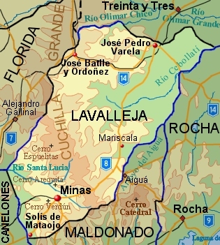
ლავალიეხას დეპარტამენტის ტოპოგრაფიული რუკა. ნაჩვენებია ძირითადი დასახლებული პუნქტები და გზები
იხილეთ აგრეთვე
- ურუგვაის დეპარტამენტები
რესურსები ინტერნეტში
- INE map of Lavalleja Department
(window.RLQ=window.RLQ||[]).push(function()mw.log.warn("Gadget "ReferenceTooltips" was not loaded. Please migrate it to use ResourceLoader. See u003Chttps://ka.wikipedia.org/wiki/%E1%83%A1%E1%83%9E%E1%83%94%E1%83%AA%E1%83%98%E1%83%90%E1%83%9A%E1%83%A3%E1%83%A0%E1%83%98:Gadgetsu003E."););
(window.RLQ=window.RLQ||[]).push(function()mw.config.set("wgPageParseReport":"limitreport":"cputime":"0.452","walltime":"0.629","ppvisitednodes":"value":12279,"limit":1000000,"ppgeneratednodes":"value":0,"limit":1500000,"postexpandincludesize":"value":93422,"limit":2097152,"templateargumentsize":"value":45246,"limit":2097152,"expansiondepth":"value":35,"limit":40,"expensivefunctioncount":"value":1,"limit":500,"unstrip-depth":"value":0,"limit":20,"unstrip-size":"value":14,"limit":5000000,"entityaccesscount":"value":1,"limit":400,"timingprofile":["100.00% 589.850 1 -total"," 91.76% 541.245 1 თარგი:ინფოდაფა_ადმინისტრაციული_ერთეული"," 86.98% 513.055 1 თარგი:ინფოდაფა"," 30.18% 178.031 167 თარგი:ინფოდაფა/რიგი"," 25.17% 148.467 33 თარგი:Wikidata"," 19.52% 115.154 3 თარგი:Str_right"," 18.54% 109.349 3 თარგი:Str_sub_long"," 18.13% 106.915 2 თარგი:გამოსახულების_ფორმატირება"," 17.23% 101.637 1 თარგი:Wikidata/p41"," 8.32% 49.051 29 თარგი:Str_index_any"],"scribunto":"limitreport-timeusage":"value":"0.117","limit":"10.000","limitreport-memusage":"value":3001108,"limit":52428800,"cachereport":"origin":"mw1269","timestamp":"20190304175322","ttl":2592000,"transientcontent":false););"@context":"https://schema.org","@type":"Article","name":"u10dau10d0u10d5u10d0u10dau10d8u10d4u10eeu10d0u10e1 u10d3u10d4u10deu10d0u10e0u10e2u10d0u10dbu10d4u10dcu10e2u10d8","url":"https://ka.wikipedia.org/wiki/%E1%83%9A%E1%83%90%E1%83%95%E1%83%90%E1%83%9A%E1%83%98%E1%83%94%E1%83%AE%E1%83%90%E1%83%A1_%E1%83%93%E1%83%94%E1%83%9E%E1%83%90%E1%83%A0%E1%83%A2%E1%83%90%E1%83%9B%E1%83%94%E1%83%9C%E1%83%A2%E1%83%98","sameAs":"http://www.wikidata.org/entity/Q460435","mainEntity":"http://www.wikidata.org/entity/Q460435","author":"@type":"Organization","name":"Contributors to Wikimedia projects","publisher":"@type":"Organization","name":"Wikimedia Foundation, Inc.","logo":"@type":"ImageObject","url":"https://www.wikimedia.org/static/images/wmf-hor-googpub.png","datePublished":"2013-01-13T16:25:55Z","image":"https://upload.wikimedia.org/wikipedia/commons/c/cf/Penitente_00.jpg"(window.NORLQ=window.NORLQ||[]).push(function()var ns,i,p,img;ns=document.getElementsByTagName('noscript');for(i=0;i-1)img=document.createElement('img');img.setAttribute('src',p.getAttribute('data-src'));img.setAttribute('width',p.getAttribute('data-width'));img.setAttribute('height',p.getAttribute('data-height'));img.setAttribute('alt',p.getAttribute('data-alt'));p.parentNode.replaceChild(img,p);});(window.RLQ=window.RLQ||[]).push(function()mw.config.set("wgBackendResponseTime":137,"wgHostname":"mw1251"););


